

Full title: Geologic Map of the Southeast Face of El Capitan, Yosemite Valley, California
Compilers: Roger L. Putnam, Allen F. Glazner, Bryan S. Law, and Greg M. Stock
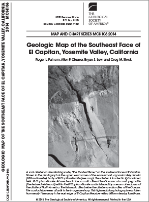
El Capitan in Yosemite National Park, California, is one of the most iconic landforms in the world. The ~1-km-tall vertical southeast face of El Capitan provides an unparalleled exposure of the interior of the Sierra Nevada Batholith at the point of interaction among seven granitic units from two intrusive suites: the intrusive suite of Yosemite Valley and the intrusive suite of Buena Vista Crest.
This unique, vertically oriented, decimeter-resolution geologic map highlights this interaction and provides a crucial third dimension to our understanding of intrusive geometry. High-resolution mapping of such an inaccessible exposure was accomplished by remote sensing using terrestrial LiDAR and gigapixel photography and was ground-truthed by climbing and rappelling. This one-of-a-kind geologic map is of interest to geoscientists and enthusiasts of national parks alike. 1 color plate (approx. 34" by 38")
Published: 8/07/2014
Product Code: MCH106F
Product Category: Maps and Charts
- Choosing a selection results in a full page refresh.
- Opens in a new window.